Produk asli Kami distributor langsung Kolida Harga murah. Pengiriman ke seluruh Indonesia.
Whatsapp : 0821 3010 0456
Email : [email protected]
CV. Syariftama Multi Global has a wide range of Kolida products – search by type, or model, or filter by brand to find the one you are after. If you still can’t find it contact us..
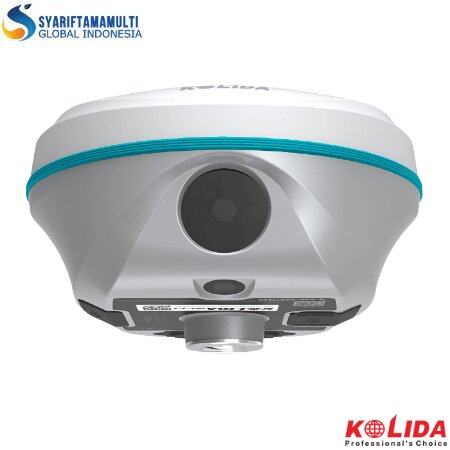
Kolida K50 is a GNSS (Global Navigation Satellite System) device that combines GPS RTK (Real-Time Kinematic) technology with advanced visual capabilities. This tool is specifically designed for surveyors and construction professionals who require high accuracy and efficiency in field work.


K50 enables single-user 3D modeling, on models that visually display geographic information such as coordinates, areas, and volumes. It supports transforming model data into different formats and customizing coordinate parameters for various applications.


This feature enables CAD drawing capabilities, previously only possible on a PC. Surveyors can now edit CAD maps on the RTK controller or on a tablet or mobile phone.
| Model | K50 |
|---|---|
| GNSS Features | |
| Channels | 1698 |
| GPS | L1, L1C, L2C, L2P, L5 |
| GLONASS | G1, G2, G3 |
| BDS | BDS-2: B1I, B2I, B3I BDS-3: B1I, B3I ,B1C, B2a,B2b* |
| GALILEO | E1, E5A, E5B, E6C, AltBOC* |
| SBAS | L1* |
| IRNSS | L5* |
| QZSS | L1, L2C, L5* |
| MSS L-Band* | Reserve |
| Positioning output rate | 1Hz~20Hz |
| Initialization time | < 10s |
| Initialization reliability | >99.99% |
| Positioning Precision | |
| Code Differential Positioning | Horizontal: 0.25 m + 1 ppm RMS Vertical: 0.50 m + 1 ppm RMS |
| GNSS Static | Horizontal: 2.5 mm + 0.5 ppm RMS Vertical: 5 mm + 0.5 ppm RMS |
| Static (long observation) | Horizontal: 2.5 mm + 0.1 ppm RMS Vertical: 3 mm + 0.4 ppm RMS |
| Rapid Static | Horizontal: 2.5 mm + 0.5 ppm RMS Vertical: 5 mm + 0.5 ppm RMS |
| PPK | Horizontal: 3 mm + 1 ppm RMS Vertical: 5 mm + 1 ppm RMS |
| RTK(UHF) | Horizontal: 8 mm + 1 ppm RMS Vertical: 15 mm + 1 ppm RMS |
| RTK(NTRIP) | Horizontal: 8 mm + 0.5 ppm RMS Vertical: 15 mm + 0.5 ppm RMS |
| SBAS positioning | Typically<5m 3DRMS |
| RTK initialization time | 2~8s |
| IMU tilt angle | 0°~60° |
| Hardware performance | |
| Dimension | 134mm(φ)×79.1mm(H) |
| Weight | 860g (battery included) |
| Material Operating | Magnesium aluminum alloy shell |
| temperature Storage | -25℃~+65℃ |
| Storage temperature | -35℃~+80℃ |
| Humidity | 100% Non-condensing IP68 standard, protected from long time |
| Waterproof/Dustproof | immersion to depth of 1m IP68 standard, fully protected against blowing dust |
| Shock/Vibration | Withstand 2 meters pole drop onto the cement ground naturally |
| Power supply | 6-28V DC, overvoltage protection |
| Battery | Inbuilt 6800mAh rechargeable Lithium-ion battery |
| Battery life | Single battery: 16h (static mode) 10h (internal UHF base mode) 12h (rover mode) |
| Communications | |
| I/O Port | 5-PIN LEMO interface (external power port + RS232) Type-C interface (charge+OTG+Ethernet) UHF antenna interface SIM card slot (Micro SIM) |
| Internal UHF | Radio receiver and transmitter |
| Frequency range | 410-470MHz |
| Communication protocol | Farlink, Trimtalk, SOUTH, HUACE, Hi-target, Satel |
| Communication Range | Typically 8km with Farlink protocol |
| Cellular mobile Network | 4G |
| Bluetooth | Bluetooth 3.0/4.1 standard, Bluetooth 2.1 + EDR |
| NFC Communication | Support |
| Modem | 802.11 b/g/n standard |
| Data Storage/Transmission | |
| Storage | 16GB SSD internal storage Automatic cycling storage Support external USB storage (OTG) The customizable sample interval is up to 20Hz Plug and play mode of USB data |
| Data Transmission | transmission Supports FTP/HTTP data download Static data format: STH, Rinex2.01 Rinex3.02 and etc. Differential data format: RTCM 2.1, RTCM 2.3, RTCM 3.0, RTCM 3.1, RTCM 3.2 |
| Data Format | GPS output data format: NMEA 0183, PJK plane coordinate, Binary code, Trimble GSOF Network model support: VRS, FKP, MAC, fully support NTRIP protocol |
| Sensors | |
| IMU Camera |
Visual positioning camera: 8MP (can be used in AR stakeout) AR stakeout camera: 2MP Controller software can display electronic |
| Electronic bubble Thermometer |
bubble, checking leveling status of the carbon pole in real-time Built-in thermometer sensor, adopting intelligent temperature control technology, monitoring and adjusting the receiver temperature |
| User Interaction | |
| Operating system | |
| Buttons Indicators |
Singlebutton |
| Web interaction | Satellites, data and power indicators With access to Web connection, users can monitor the receiver UI via WiFi or USB status and change the configurations |
| Voice guidance | Chinese/English/Korean/Spanish/ Portuguese/Russian/Turkish/French/Italian |
| Secondary development | Provides secondary development package, and opens the OpenSICobservation data format and interaction interface definition |
| Cloud service | The powerful cloud platform provides online services like remote management, firmware updates, online registers, etc |
 Kolida K50 Datasheet
Produk asli Kami distributor langsung Kolida Harga murah dan berkualitas bergaransi tentunya. dapat di kirim ke seluruh wilaya Indonesia.

CV. Syariftama Global Indonesia berdiri sejak tahun 2017 merupakan online store yang menyediakan GPS, Alat Ukur & Alat Lab, Survey Pemetaan, Komunikasi dan Drone. Silahkan berbelanja dengan aman dan nyaman. Anda juga bisa langsung datang ke toko kami.


